Sandy
[From Samuel Lewis's Topographical Dictionary of England 1831.]
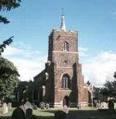
SANDY, a parish partly in the hundred of WIXAMTREE, but chiefly in that of BIGGLESWARE, county of BEDFORD, 3¼ miles (N. by W.) from Biggleswade, containing, with the hamlets of Beeston and Gritford, 1392 inhabitants. The living is a rectory, in the archdeaconry of Bedford, and diocese of Lincoln, rated in the kings's books at £32.2.11., and in the patronage of F. Pym, Esq. The church is dedicated to St. Swithin. The river Ivel runs through the parish, and is crossed by a bridge at Girtford. Galley hill is the site of the ancient Roman station Salin£, which commanded another at Chesterfield, a piece of ground, still so called, near the village, through which passed the great road from Baldock in Herts, across this county, into Cambridgeshire. The ramparts, which enclose an area of thirty acres, are surrounded by a deep fosse, and in the centre is a mount, probably thrown up for the pr£torium. At some distance, on the other side of the valley, are the remains of C£sar's camp. Several Roman urns, coins, and fragments of a beautiful red pottery, have been discovered at Chesterfield; the latter, which was ornamented with figures, has been deemed the ancient Samian ware. Owing to the sandy nature of the soil, cucumbers are cultivated in the open air in such abundance, that Covent-Garden market, London, is almost wholly supplied with that vegetable from this place.